Lake Level and River Flow

Before 1941
Up until 1941, Lake Taupo was a natural lake, this changed when control gates were installed at the head of the Waikato River which is the only exit from Lake Taupo. The Waikato River was to become a river for hydro power generation. This was done by the government through the New Zealand Electricity Department. Over the next 23 years a total of 8 hydro dams were built producing 994MW of electricity.
Deregulation
On 1st April 1987, the government took the first step towards deregulating the electricity sector and formed the Electricity Corporation of New Zealand (ECNZ). In 1996 ECNZ was split into two State Owned Organisations - ECNZ and Contact Energy. Later, on 1st April 1999 ECNZ was split into three competing companies – Meridian Energy, Genesis Energy and Mighty River Power which is now Mercury Energy. Control of the hydro stations on the Waikato River and the level of Lake Taupo were given to Mercury Energy. The Tongariro River along with the diversion flow through the Tokaanu Power Station is the major flow of water into Lake Taupo. The Tongariro Power Scheme and subsequent river flow is controlled by Genesis Energy.
Lake level
The lake is managed by Mercury Energy under resource consent #105226 within a range and at an average level consistent with that which occurred naturally prior to the installation of control gates. The main change has been one of seasonality whereby the level is held on average 0-10cm higher than it would naturally be over summer-autumn and lower than it would naturally be over winter-spring in order to meet the demand for power generation. Extreme high levels have also been reduced under management, resulting in an operating range of approximately 1.5m vs 1.75m prior to the controls. A summary analysis of historic lake levels undertaken by AFTR in 2025 is contained in our library under Environmental and Scientific.
It should be noted that the lake-bed and surrounding land is subject to continuous, non-uniform tectonic deformation (subsidence and uplift), punctuated by volcanic and seismic activity. This causes both gradual and sudden changes to the levels of different parts of the lake-bed and surrounding land, and where there is subsidence this can have the same appearance and effect as lake level rise, only localised. It can also raise the level of the water table making affected land more susceptible to ponding. These impacts are well documented to have affected the south western area of the lake and foreshore. Section 4.3 of the Taupo District Flood Assessment Report – Tongariro River, OPUS Consulting 2011 provides a useful explanation of this process which you can see at Tongariro River Flood Assessment.
Current lake levels and flow rates into the Waikato River can be found on the Mercury Energy website - https://www.mercury.co.nz/lakelevels.

River Flow
The Tongariro River originates in the Central Plateau of the central North Island, and originally the Waikato River. In 1945 the section from the Waihohonu Stream down to Lake Taupo was named the Tongariro River. It has a large catchment area extending from the eastern slopes of Mounts Tongariro, Ngauruhoe, and Ruapehu and into the Kaimanawa Ranges. The catchment area contains a number of major tributaries including the Waihohonu Stream, the Waipakihi River, and Poutu Stream.
On average 10,700 tons of gravel and larger size sediment is carried past Turangi each year with ten times this amount of finer sized material including sand. Section 2 of the above mentioned OPUS report provides a comprehensive description of the geology of the river and catchment, and the natural process of riverbed aggradation in the lower sections.
The flow of water down the Tongariro River have been continuously recorded since 1957 by a gauge located at Turangi. The flow was altered with the construction of the Tongariro Power Scheme. At Turangi, a normal flow is ~20 - 30 cu m/sec, with two extreme floods recorded in 1958 and 2004, both exceeding 1400cu m/sec. The resource consent requires that as part mitigation for the loss of recreational amenities on the Tongariro River, Genesis Energy must divert water into the river for three weekends per year. This is separate from any maintenance or flushing flows that may be necessary. The dates for these recreational releases are set in conjunction with Whitewater NZ. The Tongariro River is New Zealand’s most fished river and is considered to be one of the best wild trout rivers in the world and consequently a draw card for anglers worldwide.
River flow information for the Tongariro
Measured at the Major Jones pool, from Genesis Energy.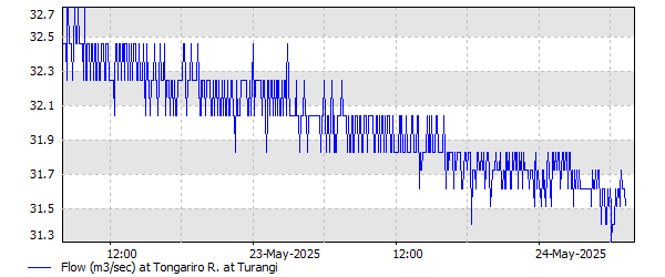
Reviewed October 2025